California History

A Personal Tie to San Fernando Citrus Industry History

by Anthony Llamas

My name is Anthony Llamas and I am a part-time liaison here at the López Adobe and the City of San Fernando. I oversee events and tours of Casa de López as well as handle property inventory. I am currently a student at California State University, Northridge and I am studying in the field of history for my undergraduate work. I plan on specializing in the interesting and amazing history of California and hope to one day work at a historic museum site or where ever this astounding profession leads me.

I grew up here in San Fernando and love learning new information about the history of the city in which I grew up. Working in the collection and archive of López Adobe has allowed me to see and read artifacts that have allowed me to learn new information about the city and the great state of California and I would love to share some of the historical artifacts I find. We’ll start with these photographs of the San Fernando Heights Orange Association and the San Fernando Heights Lemon Association.  

A circa 1920s or 1930s photo, from the López Adobe collection, of the San Fernando packing house used by the orange and lemon associations in the area.

There is no surprise that Southern California’s citrus industry was a large one in the early to mid-20th century, but exactly how big was it? Well, of the twelve counties in northern, central, and southern California that produced citrus, six of those latter in the south were known as the “citrus belt”.  Southern California accounted for ninety percent of the state’s acreage in citrus trees and became the predominant product that boomed Southern California’s economy.

From 1890 to 1960, citrus produced more wealth for California than gold did during the gold rush; during this time California accounted for sixty percent of the nation’s citrus production, and twenty percent of the world’s supply of citrus. The citrus industry helped grow the population of California as well as bring tourism into this great state. On the side of the citrus crates that were shipped across the U.S. for consumption were labels of romanticized images of California made to bring people in and it worked. The labels served three purposes: identifying the product in the crate, identifying the packing house, and bringing in tourism. The labels were pasted on the end of each fruit crate and, to attract more business, the artist used bright colors and vivid artwork.

As noted in the post, much of the work in the packing houses was conducted by women, almost exclusively Latinas, as this ca. 1920s/1930s image of the San Fernando facility interior from the Adobe holdings shows. Note the boxes with the “Sunkist” brand on them.

During this time, the picker communities, which were predominantly Latino, evolved from living in camps to establishing some of the first suburban neighborhoods in Southern California. These consisted of field hands, packers and packing house employees and this was the case for the city of San Fernando, as well. There were many citrus farms in it, as well as around the Valley, and a citrus packing house.

At the beginning of World War II, there were 11,000 acres of lemon, orange and grapefruit trees and ten packing houses in the San Fernando Valley. Not only this, but twenty-five percent of the citrus grown in this area supplied Vitamin C for the United States armed forces and its allies. The city of San Fernando contained the packing house for the San Fernando Heights Orange Association and the San Fernando Heights Lemon Association and was located on Sepulveda and San Fernando Mission boulevards. It also provided many jobs for women around the area, while the packing houses generally were a major source of employment for the Latinos of the community.

Another great image, perhaps from 1920s or 1930s, from the López collection showing Latinas at work with the processes described in the post.

Among these were some of my ancestors. My grandfather, Daniel Llamas, and his family, grew up working in the ranches and fields of the San Fernando Valley and around Southern California.  My great-grandmother Jacoba Llamas, and other family members and friends, who have since passed, worked in the San Fernando Heights citrus packing house. These were warehouses where, after they picked the fruit off the trees in the fields, they prepared the citrus to be sent out across the nation for consumption. Before the oranges and other fruits were packed in crates, they were washed, sized and graded, wax was applied for preservation, and, finally, the fruit was wrapped in tissue paper.

I love finding artifacts in the storage room, especially those with which I can make a personal connection with since my family has been here for a few generations. I will continue to share the history of the area, while providing personal connections and telling a story with items found in the Lopez Adobe archive, as well as share amazing and neat artifacts that I find interesting. Please feel free to leave a comment and, if you have a similar family connection with the citrus industry in San Fernando, please feel free to share your family’s experiences or connections.

Categories: California History, Citrus history, Lemon industry, Orange industry San Fernando, San Fernando Heights Lemon Association, San Fernando Heights Orange Association, San Fernando History, San Fernando photographs | Tags: , , , , , , , , , , , , , , , | 2 Comments

López Adobe Movie Night: A Different Experience


20160930_183530

Andrea Brooks Rynders, a great-great-granddaughter of the Lopez Adobe’s long-time owners, Gerónimo and Catalina Lopez, gives a tour to visitors at last evening’s movie night.

Last night was another movie night presentation at the López Adobe, this time with the screening of the 1941 classic Casablanca, starring Humphrey Bogart and Ingrid Bergman.  The program was part of a series sponsored by the City of San Fernando’s Parks and Recreation Department.

The inflatable screen and projector were set up on the north end of the property near the storage and restroom building, while tours of the Adobe were offered for about two hours prior.

20160930_190644

The location of the screening of the 1941 classic film, Casablanca, in an open area on the north end of the López Adobe property.  The city’s parks and recreation department put on this great series and council member Jaime Soto introduced and discussed the movie with guests.

Visitors to the house had the great experience of touring the early 1880s landmark with Andrea Brooks Rynders, great-great-granddaughter of Gerónimo and Catalina Lopez, the home’s owners for nearly four decades.

It’s one thing to hear the story of a family and house, but another matter entirely to get that from a descendant.  It’s something that people don’t get to do all that often and Andrea is carrying on the knowledge of her family and the house passed on through her father, the late John Brooks, who, sadly, passed away just before the López Adobe’s reopening in March 2015.

20160930_190615

The López Adobe takes on different visual qualities when photographed at dusk with the lighting and the colors in the sky adding to the scene.

It was also another type of experience to be in the López Adobe at night, especially when the evening is cooler after a warm day, the building is lit up, and downtown San Fernando activity quieter.

As some of the photos here show, the Adobe takes on a really luminous quality when photographed at night (even from obviously amateur images like these!)  That’s why the movie night is such a great idea.  Not only do visitors get to see interesting films with commentary by city council member Jaime Soto, but they can see and experience the house in a different way.

20160930_190707

With palm, orange and pomegranate trees in silhouette and exterior lighting on the house, the López Adobe looks pretty awesome at night.

The next opportunity for vistors to see the Adobe won’t be at night, but come out and take a tour and learn about the interesting history of the López family, their long-time home and the area on Sunday, 23 October from 1 to 4 p.m.

Categories: California History, Catalina Lopez, Downtown San Fernando, Geronimo Lopez, Lopez Adobe, Lopez History, San Fernando buildings, San Fernando History, San Fernando photographs | Tags: , , | Leave a comment

Movie Night at Lopez Adobe on 22 July!

The City of San Fernando is hosting a movie night at the Lopez Adobe a week from tomorrow, on Friday, 22 July.

The event includes free guided tours of the early 1880s adobe landmark at 6 p.m. with the film presentation of 1939’s Juarez, starring Oscar winners Paul Muni and Bette Davis in this tale based on the French occupation of México during the 1860s.

Muni played Benito Juarez, the Mexican president who was ousted by the French and established his exiled government on the American border at Ciudad Juarez.  Claude Rains, another great actor, played French emperor Napoleon III, Brian Aherne, a fine character actor, performed as the puppet Emperor Maximilian and Davis playing the Belgian-born Empress Carlota.

Lopez Adobe Movie Flyer.7.2016

The cast also includes the great John Garfield as Porfirio Diaz and such veteran performers as Donald Crisp, Gale Sondergaard, and the only Mexican among the main cast, Luis Antonio Dámaso de Alonso, a native of, ironically, Ciudad Juarez, who went by the stage name of Gilbert Roland and who was a silent star before he emerged later as an excellent character actor.

San Fernando City Council member Jaime Soto will discuss the film as part of the event, which is free, so plan on coming out to enjoy the Lopez Adobe and the movie.

For more information, call 818.898.1290.

Categories: California History, Downtown San Fernando, Lopez Adobe, San Fernando History | Tags: , , , , , , , , , | Leave a comment

An 1866 Map from the Lopez Adobe Collection

It’s in pretty sorry shape overall, but a scrapbook repurposed to hold an atlas from Augustus Mitchell’s collection of maps from 1866 included one of California, a detail of which is reproduced here, is in the Lopez Adobe collection.

The map shows the Los Angeles region at a crucial time.  The Civil War had just ended and the area was poised to undergo its first boom, as migrants came in larger numbers than before.

It was an opportune time because heavy flooding in 1861-62 (El Niño) followed by two years of severe drought (La Niña–ring a bell?) ravaged the cattle industry and drove land prices down.

DSCN6970

The boom really took off in 1867, the year after the appearance of the map, and continued until 1875 when it went bust in a big way.  Of course, San Fernando was created at the end of that period as a railroad town along the line of the Southern Pacific being built north from Los Angeles.

Among the interesting features of the map, which was hand-colored in each printed copy, are that the local counties included Santa Barbara (blue), San Bernardino (pink), Los Angeles (yellow) and San Diego (blue).  Ventura, Riverside and Orange counties were off in the future.

Note, too, that the San Gabriel Mountains are referred to here as the San Bernardinos (now the chain east of Cajon Pass; the San Gabriels were often referred to in this era as the Sierra Madre range).

The dotted lines represent the two main roads in the region.  East from Los Angeles through San Gabriel and San Bernardino was the road leading out towards Arizona.  From the rudimentary harbor at San Pedro to Los Angeles was roughly today’s Interstate 110.  Then from Los Angeles north was San Fernando Road leading up to the San Fernando Mission and then up San Fernando (Newhall) Pas and towards Tejon Pass and the Central Valley.

It’s also interesting to see the San Gabriel River terminating at the Los Angeles River.  This is the channel of what is now the Rio Hondo.  In the winter of 1867-68, which featured torrential rainfall, the San Gabriel changed to its present course.

Most of the Channel Islands, the San Juan Capistrano and San Gabriel missions, Elizabeth Lake and Thompson’s stage stop near it, Santa Susana Pass, Point Fermin and Point Dume, Cajon Pass, and two unfamiliar names to most–“Las Yerbas,” meaning the Yorba Ranch near modern Corona, and Las Flores, or where Camp Pendleton is now–are notable locales.

The Lopez Adobe collection has a great many interesting items and this map is one example!

Categories: California History, Lopez Adobe, Los Angeles maps, Mission San Fernando, Newhall Pass, San Fernando History, San Fernando Pass, San Fernando Road | Tags: , , , , , , | Leave a comment

The Porter Land and Water Association

Porter Land and Water pamphlet

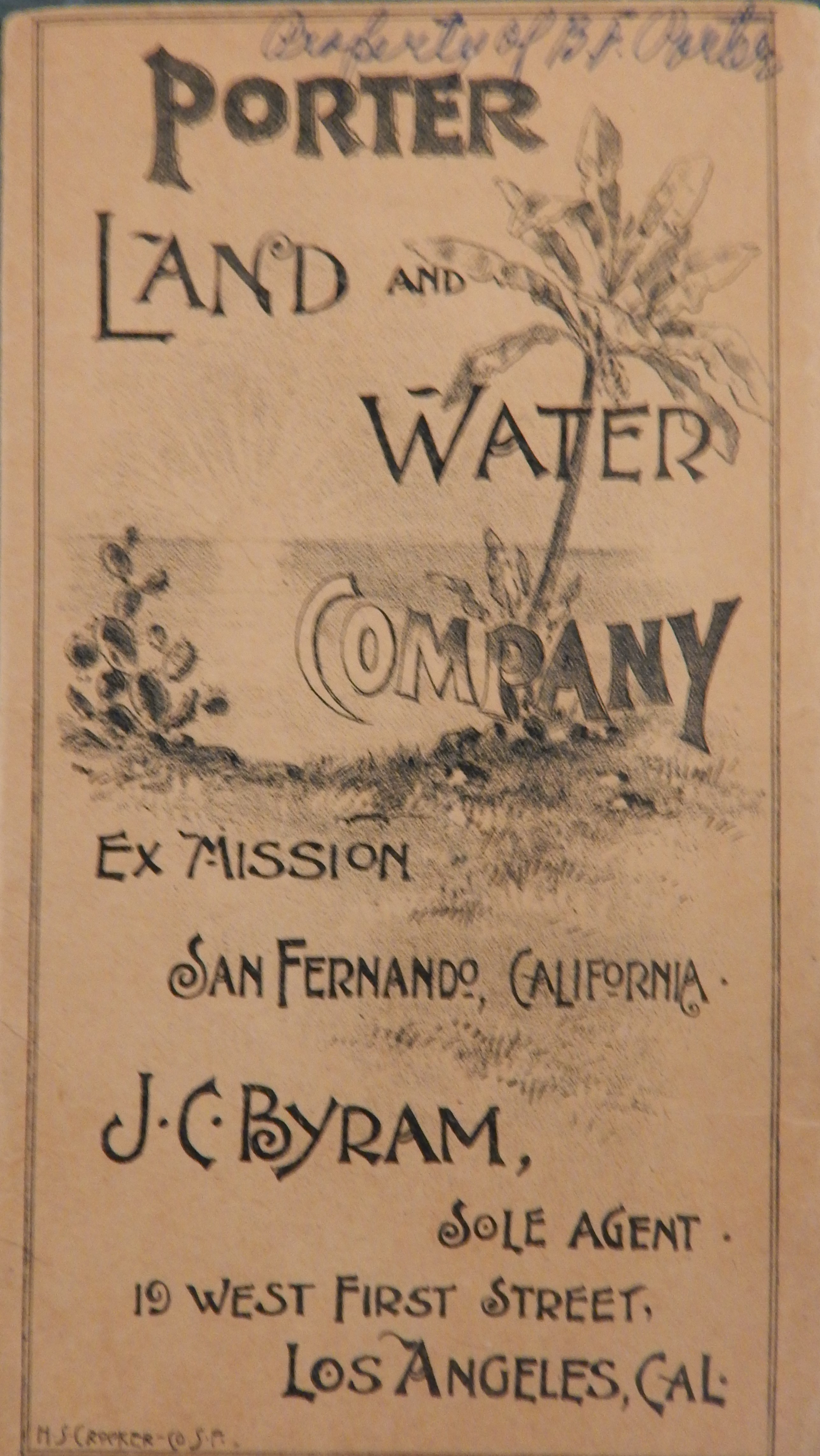
Cover of a circa 1889 promotional pamphlet for the Porter Land and Water Company, from the collection of the Lopez Adobe.

Another great recent find in the Lopez Adobe collection was an original circa 1889 pamphlet for the Porter Land and Water Company, which subdivided a 20,000-acre section of the former Rancho ex-Mission San Fernando that was formerly the ranch of George K. Porter.

In 1874, Robert Maclay created the townsite of San Fernando during the Los Angeles region’s first boom period, which began in the late 1860s and brought thousands of new residents to the area.  Other towns that sprung up during this period included Pasadena, Pomona, and Artesia, but, by 1876, the boom went bust and most of these communities stagnated for a decade.

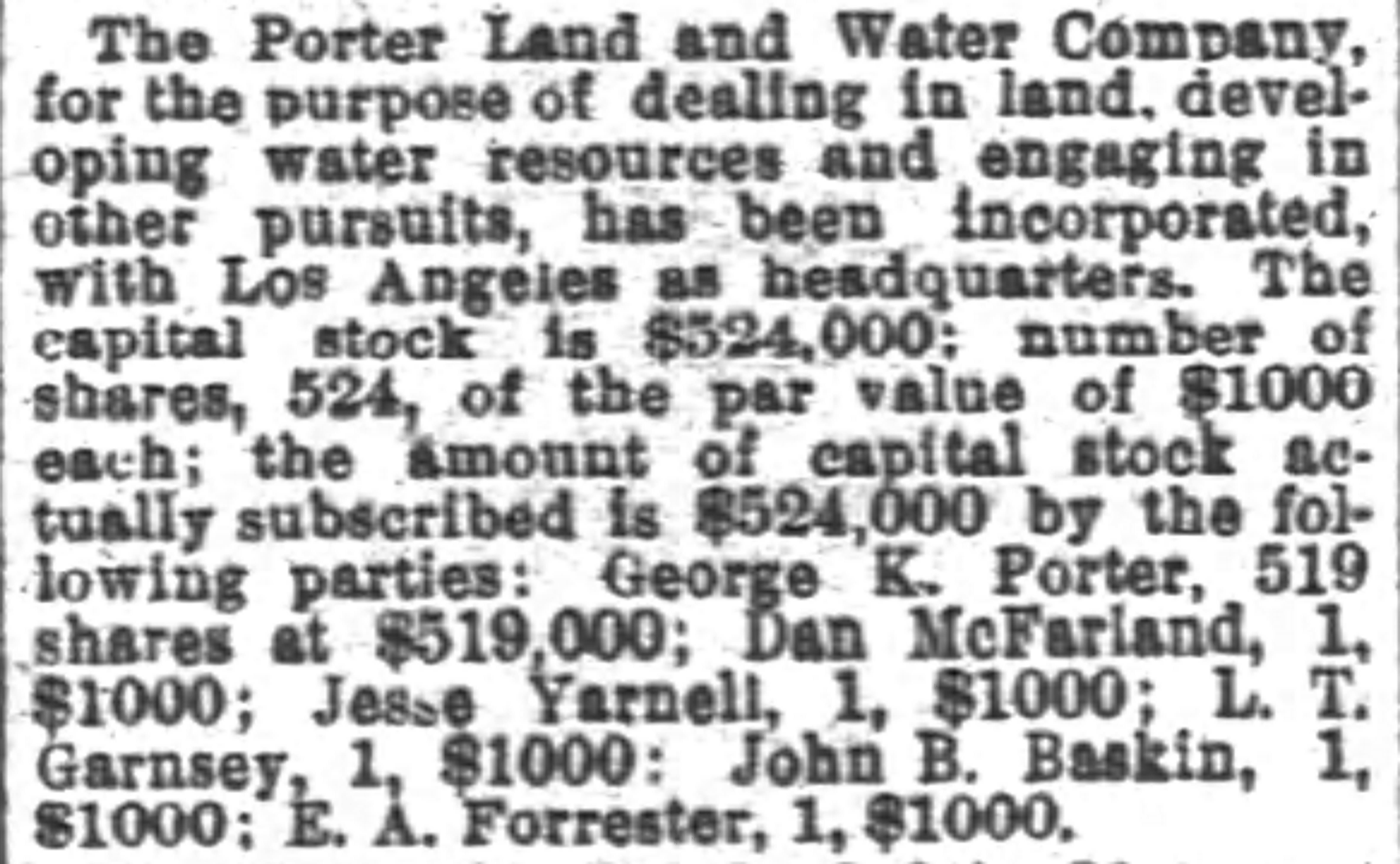
But, with the arrival of a direct transcontinental railroad, the Santa Fe line, from the east in 1885, a new boom arose and this one was far larger than its predecessor.  As new arrivals poured in, more land was subdivided and placed on sale for steeply-rising prices.  George K. Porter jumped at the opportunity and launched the Porter Land and Water Company, capitalized at over $500,000.


San_Francisco_Chronicle_Fri__Jun_3__1887_

San Francisco Chronicle, 3 June 1887.

He took almost all of the stock, with a few partners investing $1,000 each for a single share.  These included Jesse Yarnell, a newpaper publisher; Dan McFarland, who invested heavily in the Boom of the 1880s; Lehman T. Garnsey, a new arrival in the area and an investor in what became Burbank; Edward A. Forrester,  a real estate developer and future county supervisor; and John B. Baskin, who became the sales agent for the new firm.

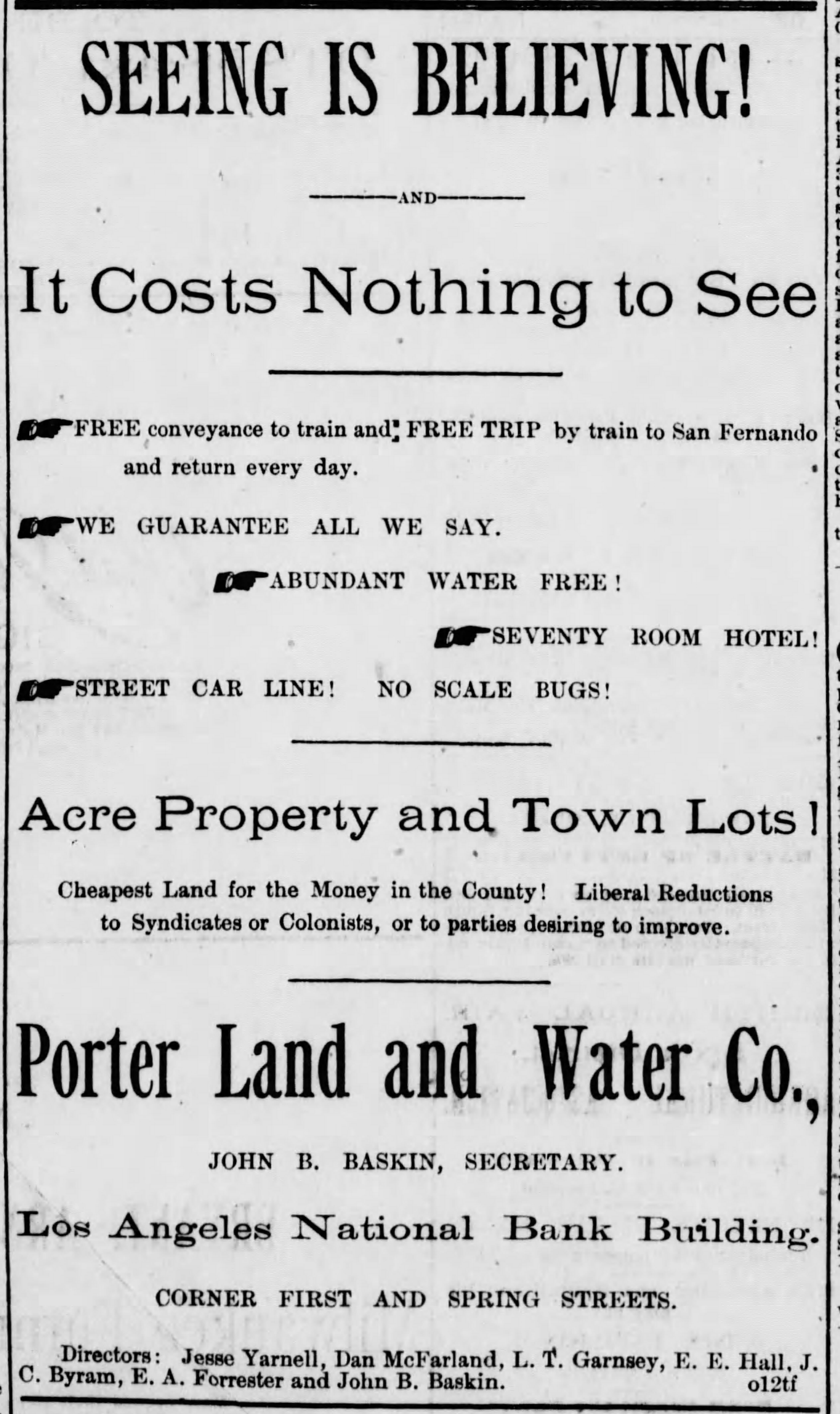
Baskin immediately began an aggressive marketing and promotional campaign for the subdivision of San Fernando-area land, doing so in a hyper-competitive environment in which almost every new project featured the finest soil, the balmiest climate, ample water and amenties galore.

One of the frequently-mentioned elements of the company’s holdings was the fact that the remains of Mission San Fernando were surrounded by the tract and the usual comparisons were made between the “days of old” represented by the crumbling walls of the mission and the progress represented in the Boom of the 1880s.

Los_Angeles_Herald_Sun__Jul_3__1887_

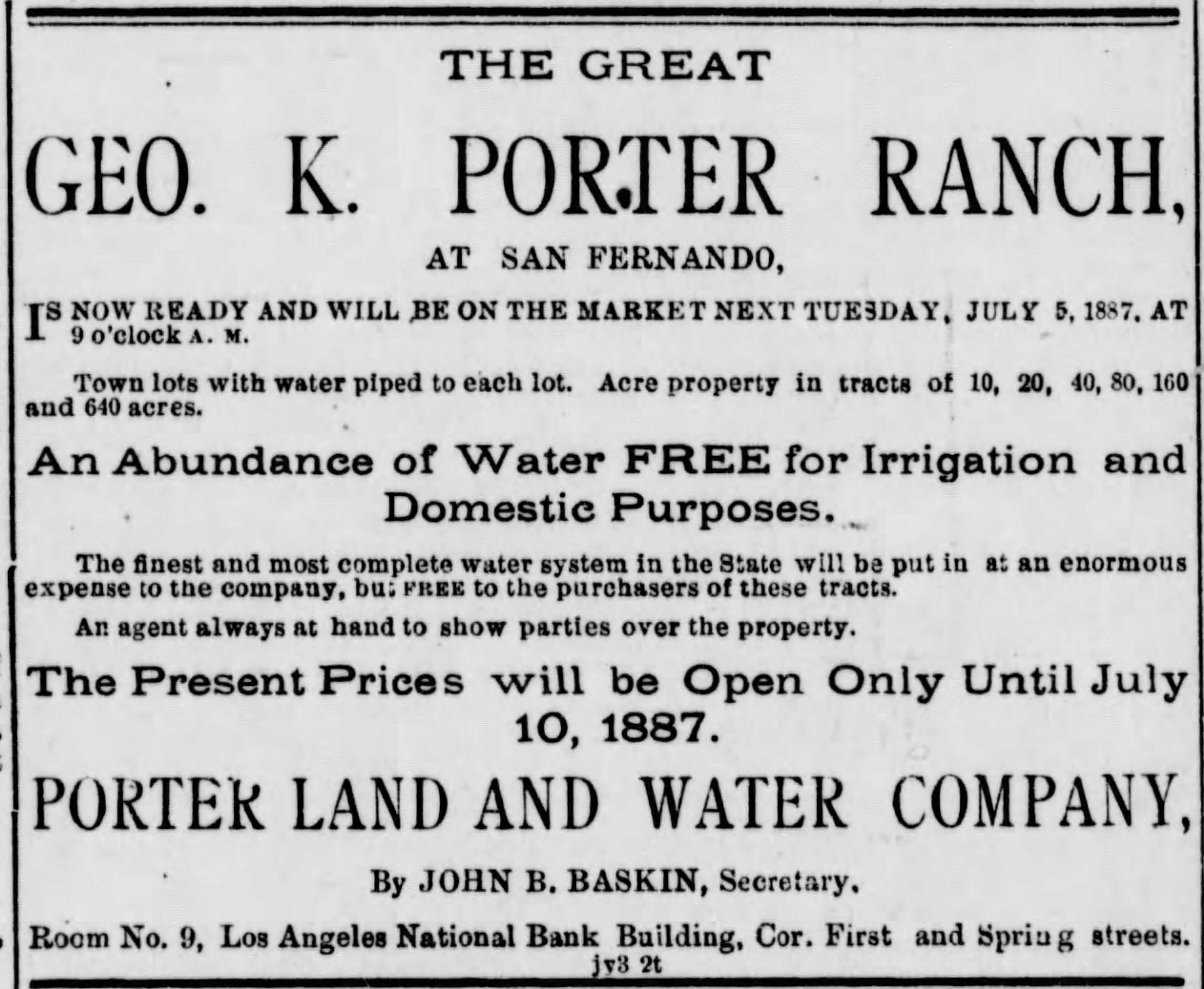
Los Angeles Herald, 3 July 1887.

The first advertisements were published in local newspapers on 3 July and sales commenced two days later, including town lots as well as parcels ranging from 10 to 640 acres.  Baskin hired William Hammond Hall, California State Engineer and an expert on water, to develop a comprehensive irrigation plan for water derived from local creeks (such as Pacoima) and springs.  Hall also offered his opinion that Porter Land and Water controlled “really first-rate valley lands for cultivation, with soils not to be surpassed for fertility” as well as “in a neighborhood  whose climate is well-adapted to the best class of agricultural, horticultural and vineyard productions usual in this country.”

On 22 July, it was announced that the firm bought a lot in San Fernando from Martin Murnane for a hotel–this became the 70-room Porter Hotel, though it was originally the San Fernando Mission Hotel.  Two days later, Baskin published a “card” in the Los Angeles Herald with a statement from long-time local residents attesting to the fact that “the oranges produced on said ranch are as fine as any we have seen in the State, and we further swear that scale bugs do not, and never have existed on any trees on the ranch.”

The signatories included Porter’s ranching partner, Henry C. Hubbard; Benigno Pico, who was married to Edward Forrester’s sister in a rare inter-ethnic marriage of the time; Southern Pacific station agent, W.H. Griswold; John T. Wilson; and Wilson’s father-in-law, Gerónimo López.  Lopez’s 25 years of residency in the area (meaning his arrival was in 1861 or 1862) was by far the longest of the eight signatories, who swore their statement before San Fernando’s justice of the peace, T.S. Smith.

Los_Angeles_Herald_Wed__Oct_12__1887_

Los Angeles Herald, 12 October 1887

In late August, the biggest sale registered by Porter Land and Water was 1,500 acres in the center of the tract to Theodore Wisendanger, a native of Switzerland, who came to Los Angeles in 1884, just before the boom erupted, for some $250,000.  Wisendanger, upon his arrival in the area, taught briefly at a little new and unknown Methodist college called U.S.C. and then dove headlong into real estate, developing some 3,000 acres and building hundreds of houses.  He also was a pioneer in building apartments, amassing a portfolio of some forty buildings, though he died poor and almost forgotten in 1919.

The Porter Land and Water Company even tried to sell stock on the new Los Angeles Stock Exchange, offering initially for the $1,000 per share price assigned in the company’s formation.  As the boom moved into 1888, the offered value rose to nearly $1,200, though it is unknown how many investors joined in.  The company did add two directors, enlarging its number to seven, that year.

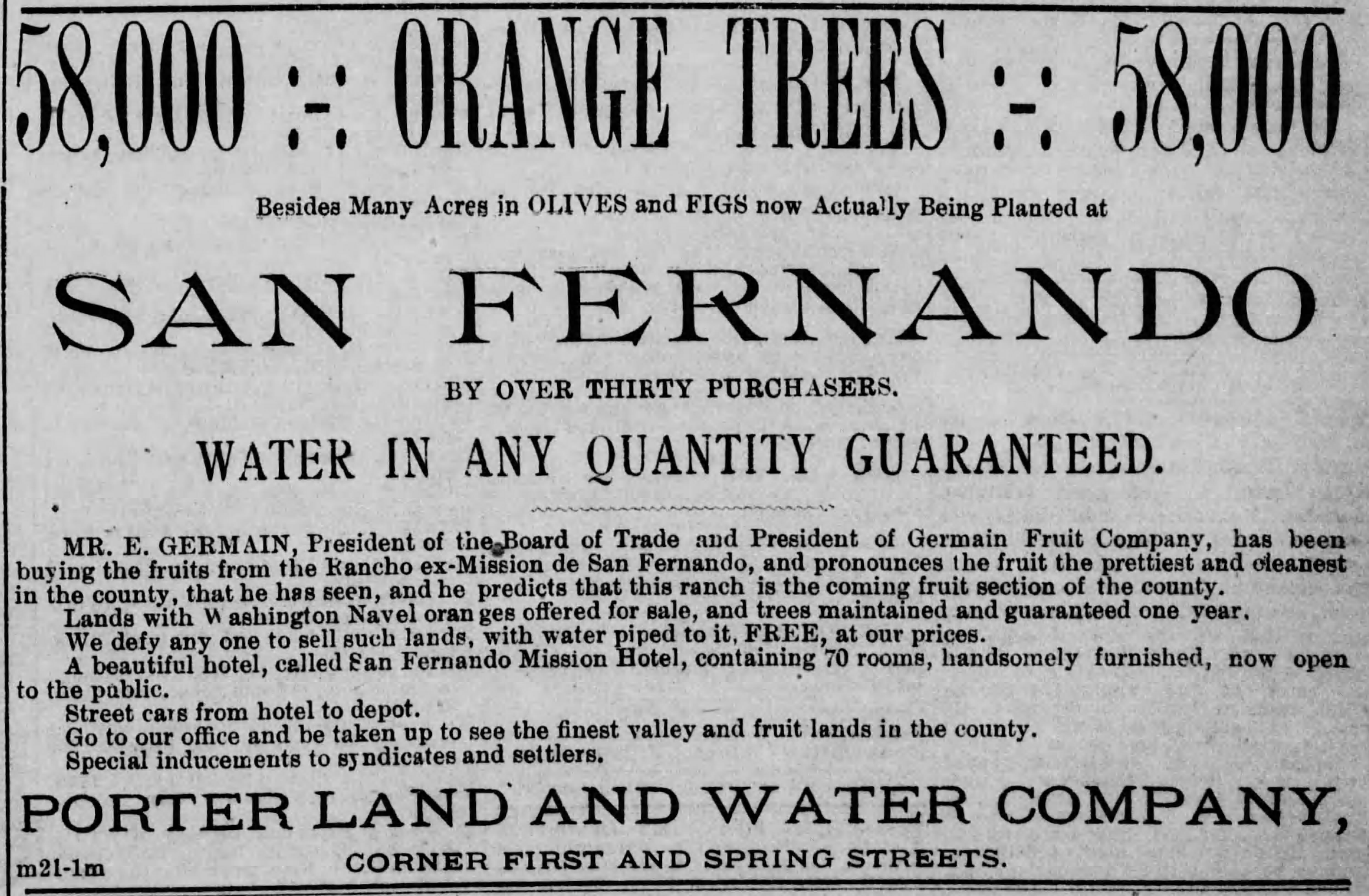
As 1888 dawned, the company was offering its land for $50 an acre, with a 40-acre lot being the most commonly marketed and sold plot.  An upfront cash payment of 1/3 was expected, with the remainder due either in one or two years at 6% interest.  In February, it was announced that a little under 500 acres of the property was being planted to oranges to demonstrate the fertility of the soil, the absence of pests, and the abundance of water that would make cirtus raising a profitable endeavor on the firm’s lands.

Los_Angeles_Herald_Fri__Mar_23__1888_

Los Angeles Herald, 23 March 1888.

Besides 58,000 orange trees, as claimed in a March advertisement, figs and olives were represented as flourishing on the Porter property.  In later years, the olive groves and production facilities at Sylmar would become widely-known.  In the ad, Baskin enlisted Eduard Germain, one of Los Angeles’ biggest fruit dealers, quoted as saying that the fruits of the company’s tract were “the prettiest and cleanest in the county” and that “this ranch is the coming fruit section of the county.”

On 6 April 1888, Porter Land and Water offered a “grand excursion” from Los Angeles to the tract with the subsidized train ride, tour and lunch only costing 75 cents.  The recently planted orange grove was touted as the largest in the world.  The Herald‘s coverage included the wording of a statement that many of the excursionists signed about the “excellent manner in which we were treated” as well as “the fine appearance of the country and the extensive improvements being made” which “prove that the land of the Company has not been praised near what it deserves.”

Porter Land and Water map 2

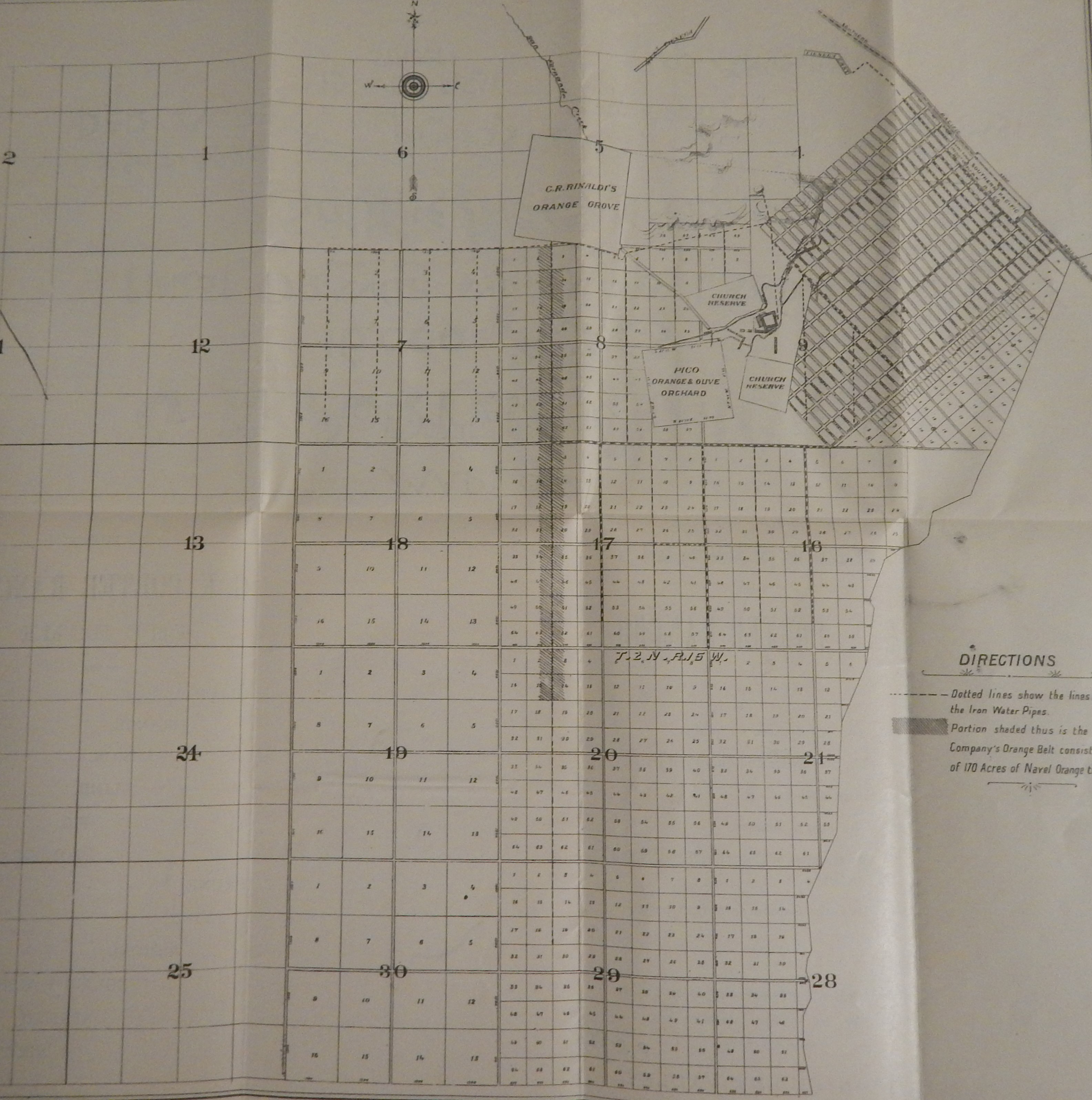
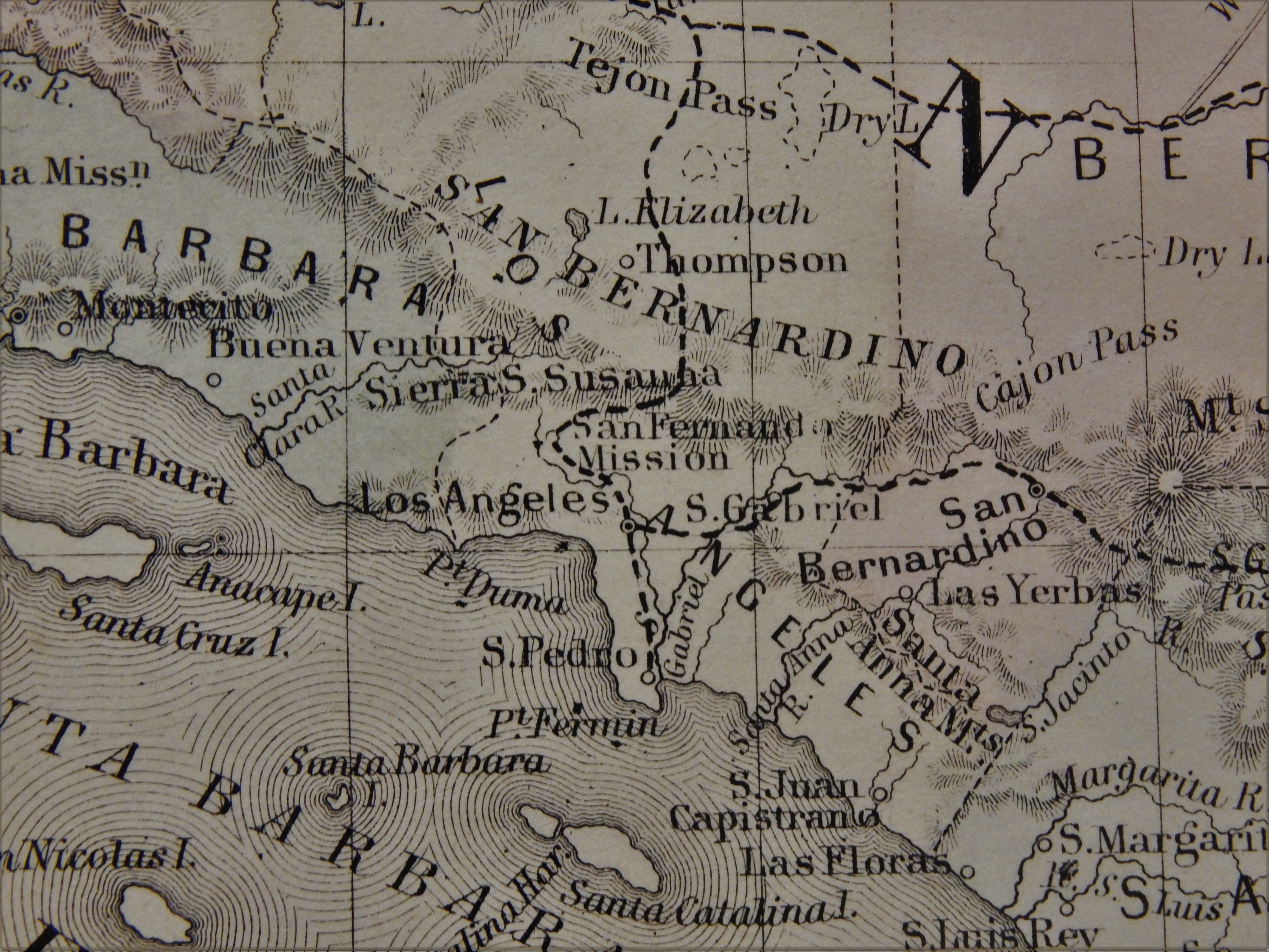
The fold-out map of Porter Land and Water Company holdings from the 1889 pamphlet.

As the year wound towards a close, the boom began to fade and problems ensued within Porter Land and Water.  On the latter point, a bookkeeper, Thomas Gaskins, forged some company checks payable to himself and skipped town, leaving his teenaged wife and infant son behind.  He was captured in San Francisco and brought back to Los Angeles for criminal proceedings, though the outcome was not located.

Early in 1889, John B. Baskin was taken to court by the company.  Baskin, it was noted was paid $100 per month and given a 6% commission on all sales as part of his work as agent, but Porter Land and Water charged that Baskin engineered “pretended” sales and collected his commission on others that were never fully realized or perfected.  The company alleged that Baskin, who received some $15,000 in salary and fees in ten months (a very large sum), also had promissory notes against the firm for other work, charged the firm $2,000 to a personal account, and had property put in the name of his wife and then transferred to him.  The total of alleged false fees and other income was some $6,000.  The firm demanded that Baskin only receive the total of his salary and commission on actual, realized and perfected sales.  While the matter did proceed in court, no outcome was located, though it may be that there was an out-of-court settlement.

By 1889, the firm had a new agent, J.C. Byram, whose name appears on the pamphlet pictured here.  Byram, however, could do little to turn around sales, when the boom was bust, and the national and local economies were heading towards a depression, which broke out in 1893.  Additionally, much of the 1890s found the region in a severe drought.

1898 Herald article

Los Angeles Herald, 23 June 1898.

An 1898 Herald article on another company lawsuit, this one against Porter, his company, and officers and directors in Porter Land and Water, was headlined “Relic of Boom Days.”  It was just a decade removed, but the glory days of the boom were already worthy of “relics” by the late Nineties.

The suit was brought by 26 “small stockholders” in the firm and they alleged that as “the years rolled by and the land did not sell,” Porter and associated borrowed $100,000 from a bank on the company’s credit, with Porter being paid some $45,650 out of the borrowed money for 734 acres that he transferred to the company.  The plaintiffs argued that the 734 acres had to be sold before Porter was paid.  The 26 stockholders won their case at the local Superior Court, but the judgment was reversed on appeal by the state Supreme Court.  The affair shows the low state of the company as the 1890s ended.

Porter Land and Water map detail

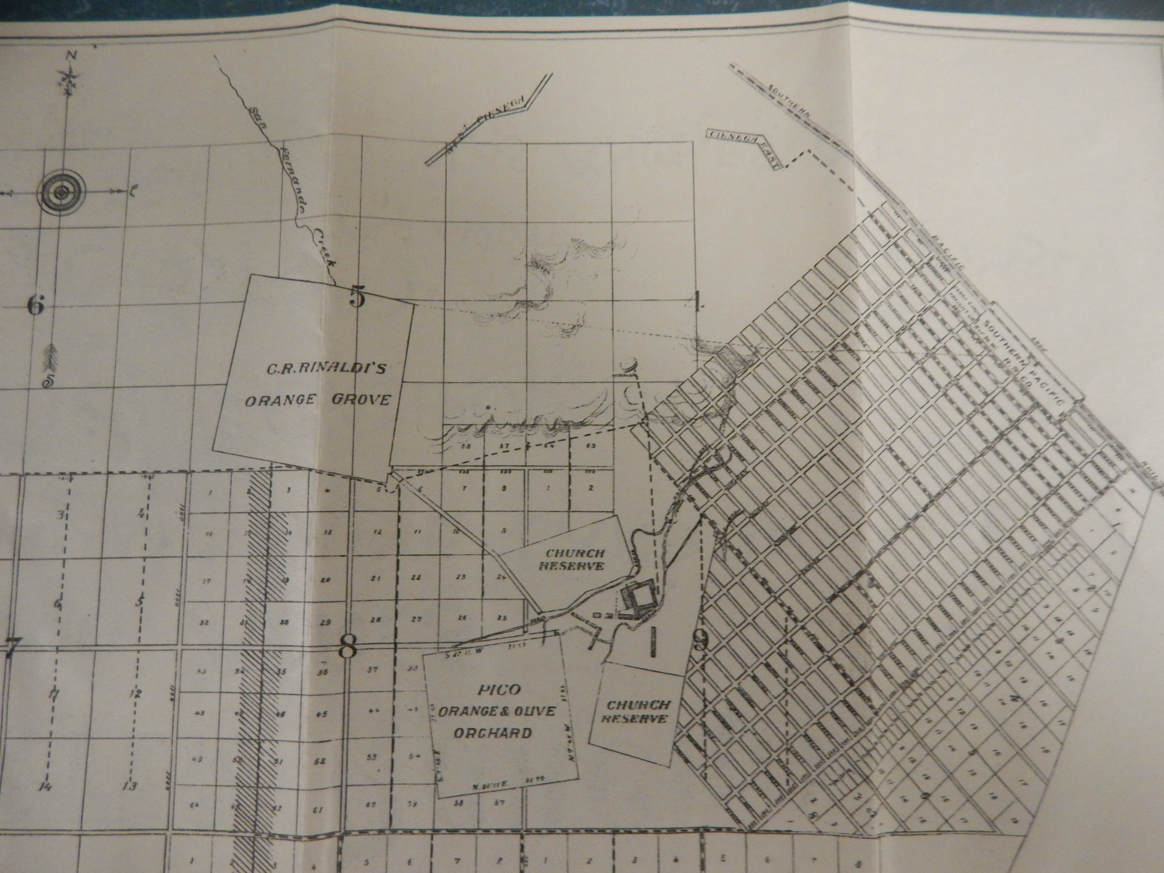
Detail from the circa 1889 map from the Porter Land and Water Company pamphlet showing the townsite of San Fernando at right, the Mission San Fernando at the center, the location of the Andres Pico Adobe at lower center, and the Rinaldi orange grove towards the upper left.

Five years later, in 1903, Porter sold his firm and transferred remaining acreage in the San Fernando area to a new company, the San Fernando Mission Land Company, of which he was a minority owner, holding 10% of the stock.  Three years after that, in 1906, he died, without much of the property he owned and developed being sold, though it was not long afterward that a new rush of settlers came to the San Fernando Valley, which was the terminus, from 1913, of the Los Angeles Aqueduct.

Categories: California History, Citrus history, George K. Porter, Geronimo Lopez, Lopez Adobe, Lopez History, Mission San Fernando, Porter Hotel, Porter Land and Water Company, San Fernando founders, San Fernando History | Tags: , , , , , , , | Leave a comment

Create a free website or blog at WordPress.com.