
It’s in pretty sorry shape overall, but a scrapbook repurposed to hold an atlas from Augustus Mitchell’s collection of maps from 1866 included one of California, a detail of which is reproduced here, is in the Lopez Adobe collection.
The map shows the Los Angeles region at a crucial time. The Civil War had just ended and the area was poised to undergo its first boom, as migrants came in larger numbers than before.
It was an opportune time because heavy flooding in 1861-62 (El Niño) followed by two years of severe drought (La Niña–ring a bell?) ravaged the cattle industry and drove land prices down.
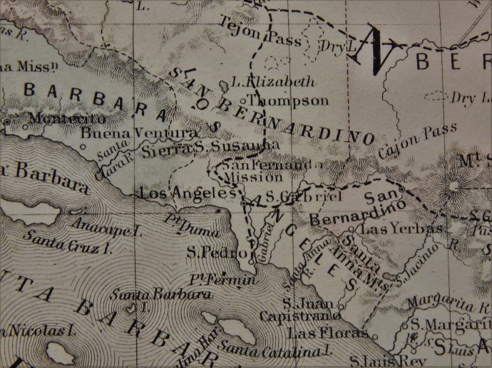
The boom really took off in 1867, the year after the appearance of the map, and continued until 1875 when it went bust in a big way. Of course, San Fernando was created at the end of that period as a railroad town along the line of the Southern Pacific being built north from Los Angeles.
Among the interesting features of the map, which was hand-colored in each printed copy, are that the local counties included Santa Barbara (blue), San Bernardino (pink), Los Angeles (yellow) and San Diego (blue). Ventura, Riverside and Orange counties were off in the future.
Note, too, that the San Gabriel Mountains are referred to here as the San Bernardinos (now the chain east of Cajon Pass; the San Gabriels were often referred to in this era as the Sierra Madre range).
The dotted lines represent the two main roads in the region. East from Los Angeles through San Gabriel and San Bernardino was the road leading out towards Arizona. From the rudimentary harbor at San Pedro to Los Angeles was roughly today’s Interstate 110. Then from Los Angeles north was San Fernando Road leading up to the San Fernando Mission and then up San Fernando (Newhall) Pas and towards Tejon Pass and the Central Valley.
It’s also interesting to see the San Gabriel River terminating at the Los Angeles River. This is the channel of what is now the Rio Hondo. In the winter of 1867-68, which featured torrential rainfall, the San Gabriel changed to its present course.
Most of the Channel Islands, the San Juan Capistrano and San Gabriel missions, Elizabeth Lake and Thompson’s stage stop near it, Santa Susana Pass, Point Fermin and Point Dume, Cajon Pass, and two unfamiliar names to most–“Las Yerbas,” meaning the Yorba Ranch near modern Corona, and Las Flores, or where Camp Pendleton is now–are notable locales.
The Lopez Adobe collection has a great many interesting items and this map is one example!

