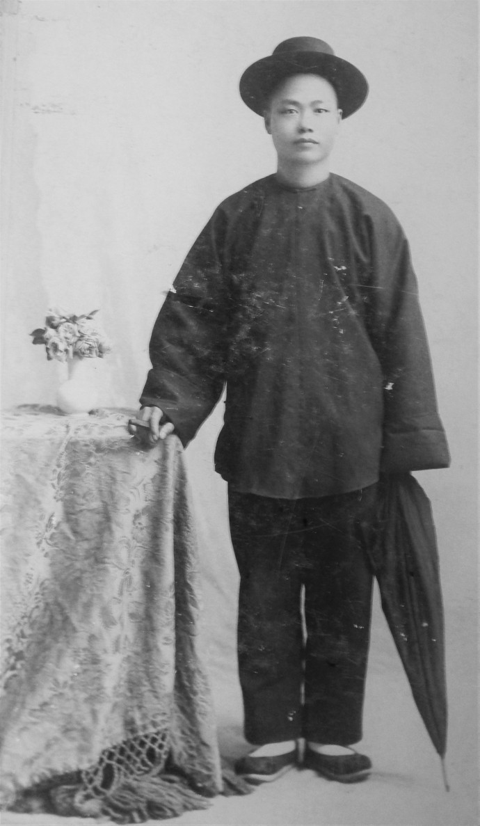
Another very interesting recent find in the Lopez Adobe photo collection is the above cabinet card portrait taken in 1896 by Los Angeles photographer Elkanah P. Tresslar. It shows a young Chinese man standing next to a small side table covered by a patterned throw with tasseled ends and on which is a small vase with flowers.
The man wears traditional Chinese clothing, including a large long-sleeved tunic, trousers and slippers. Yet, he also wears a smart, contemporary Western-style hat, holds an unbrella in his left hand and, in his right hand, resting on the edge of the table, is a cigar. The combination of the new and old, Chinese and American, is striking and certainly deliberate.
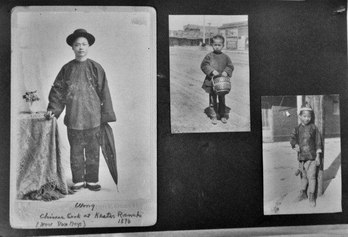
At the bottom over the Tresslar’s stamped name and address is an inscription that reads “Wong / Chinese cook at Kester Ranch / (Now Van Nuys) 1896.” The photo is mounted on a photo album page which also has two pasted-down snapshots of Chinese boys, one appearing to be about eight or nine years old and the other perhaps a couple of years older than the other.
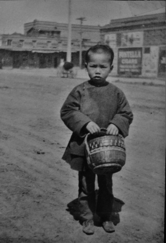
The younger of the two stands in the middle of a wide, dirt street and wears similar clothing to Wong, a dark-colored tunic and trousers, though he wears Western shoes. Held in both hands in front of him is a woven basket, almost as if he was carrying a lunch in it. In the distance is an intersection with portions of buildings, one of which has a “Fontella Cigars” ad on the side.
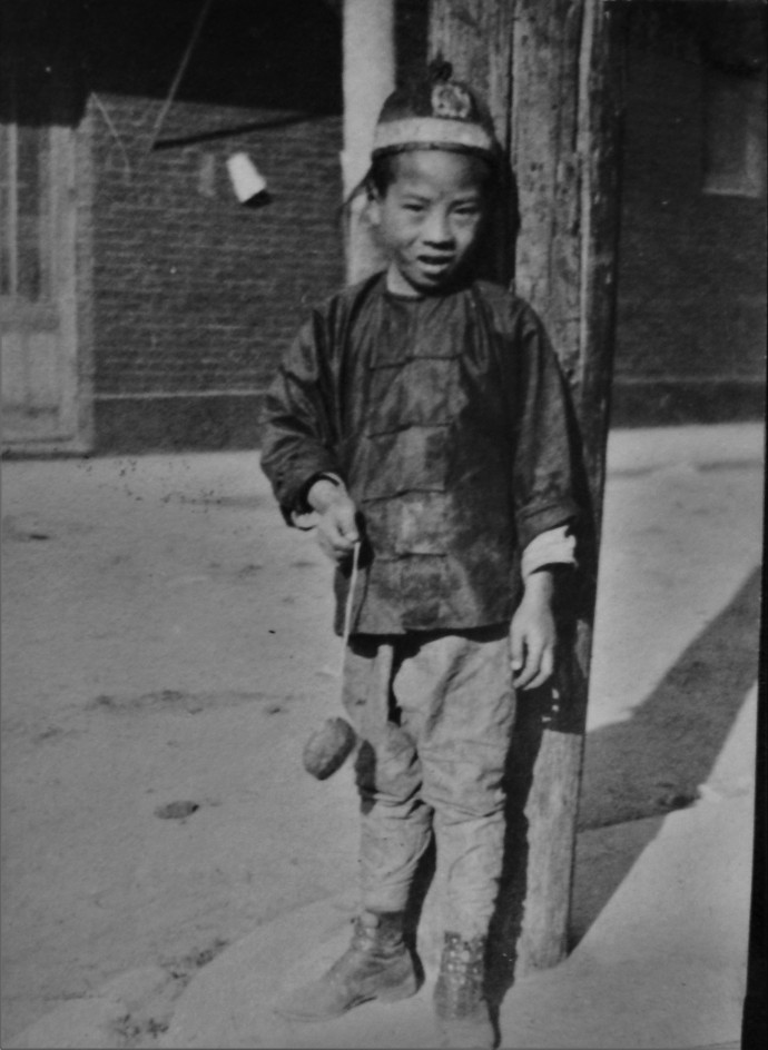
The older stands next to a wooden power pole and wears a traditional Chinese tunic and skullcap, though his trousers appear to be Western and he also sports lace-up boots. In his right hand he holds a foot-long or so piece of string at the end of which is an oval object, perhaps a piece of food or a stone. Behind him is a small side street and part of a brick building. In fact, the pole and building might even be the one in the distance in the other photo of the younger boy.
More than likely these two snapshots were taken at Los Angeles’s Chinatown, which was on the site of today’s Union Station. The original Chinese neighborhood, from the 1860s to the 1880s, was the infamous Calle de los Negros, a narrow, adobe-lined street to the southeast of the Plaza and which was where the horrific massacre of nineteen Chinese men (one a teenage boy) took place in 1871. When the calle was rerouted into Los Angeles Street, the Chinese moved east across Alameda Street to a new area.
The photo with the younger boy could well be on the west side of Alameda looking northeast towards the Chinese enclave. As Union Station was in the planning and construction stages, Chinatown moved to its current location to the north and west.
What is unknown is what relation the two boys might have had to Wong, the Kester Ranch cook, or how the album page came to the Lopez Adobe collection. As to the Kester Ranch, here is some information about it.
John Hamilton Kester was born in Boston, New York, southeast of Buffalo in 1828. He remained there until at least the mid-1850s, when he migrated to northern California and settled in Napa County, specifically in Yountville in the heart of today’s famed wine-making area. Kester became a wheat farmer and miller and lived later in Tehama County near Red Bluff and in Orland at Colusa County, both in the upper Central Valley. At the end of his life he resided in San Francisco.
Apparently, one of his friends from New York was Isaac N. Van Nuys, who was born in 1836 and who hailed from West Sparta, about fifty miles west of Kester’s hometown of Boston. When Van Nuys left New York and came to California in 1865, he settled at Yountville, where Kester still lived.
Within a few years, however, Van Nuys visited Los Angeles and took a liking to the area, buying an interest in the recently established San Fernando Farm Homestead Association, which, in July 1869, acquired 60,000 acres of Rancho ex-Mission San Fernando (the $115,000 was used by former governor Pío Pico to build his three-story Pico House hotel on the Plaza in Los Angeles). The principal figure in the association was Isaac Lankershim, who was joined by Van Nuys. Their relationship was cemented when Van Nuys married Lankershim’s daughter, Susan.
The Lankershim-Van Nuys partnership initially focused heavily on the raising of sheep, but drought conditions led them to pull back on that emphasis and they sold their stock of 25,000 animals in 1882. Instead, the impetus moved towards large-scale wheat farming operations through the Los Angeles Farm and Milling Association, which comprised thousands of acres of fertile land that generally produced high yields. Lankershim also built a flour mill in downtown Los Angeles and the enterprise flourished.
Kester appears to have been given an option to acquire some 13,000 acres about 1878 and began work on his new ranch. But, as reported in the Los Angeles Herald, in September of that year, a massive brush fire of up to 3,000 acres, suspected as an arson fire, broke out at Tujunga and spead to the lower part of the San Fernando Valley and the ranches of Lankershim and Kester, devouring wheat fields. Kester and fifty men saved a good deal of property from destruction by burning and plowing a circle around grain, machinery and livestock.
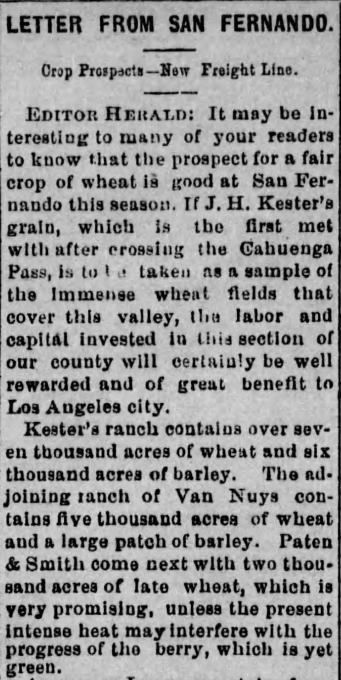
Still, in June 1879, a Herald article in the form of a “Letter from San Fernando” observed that expectations for a good season in wheat farming could be seen by the work underway at Kester’s ranch, described as “over seven thousand acres of wheat and six thousand acres of barley.” Meanwhile, “the adjoining ranch of Van Nuys contains five thousand acres of wheat and a large patch of barley.” Another was the ranch of “Paten & Smith.” likely the attorneys George H. Smith and George S. Patton, Sr., whose son was the famed World War II general.
Kester registered to vote in the San Fernando township in 1879, listing himself as a farmer. But, by the time the 1880 federal census was conducted, he was residing in Tehama County. Still, an August 1881 Herald notice stated that “Mr. Kester, of the San Fernando valley, finished threshing his wheat on Wednesday, the crop yielding in the neighborhood of 30,000 sacks,” indicating he may have been owner of the ranch while not residing on it.
It also appears the size of the property dropped down to 7,000 acres, based on a May 1883 article describing the ranch, based on information provided by its superintendent, but the Herald referred to the property as the “Kester” ranch. In September, the paper stated
A contemporary speaks in the superlative degree of the Kester Ranch in San Fernando with its crop of 40,000 sacks. As Kester never had a ranch here, and has not been in the county since 1879 a reference to him appears a little antiquated to say the least.
Obviously, Kester did have some interest in the property, as noted in the 1878-1881 references above, but he clearly distanced himself from the ranch not long afterward. Just what happened when is not clear, but, in 1890, a boiler explosion on the property made note of the location as “the Kester ranch of I.N. Van Nuys.” This makes it appear as if Kester sold his interest to Van Nuys sometime after summer 1881. When the photo of Wong, the ranch cook, was taken in 1896, it is obvious he was serving in that capacity for ranch workers.
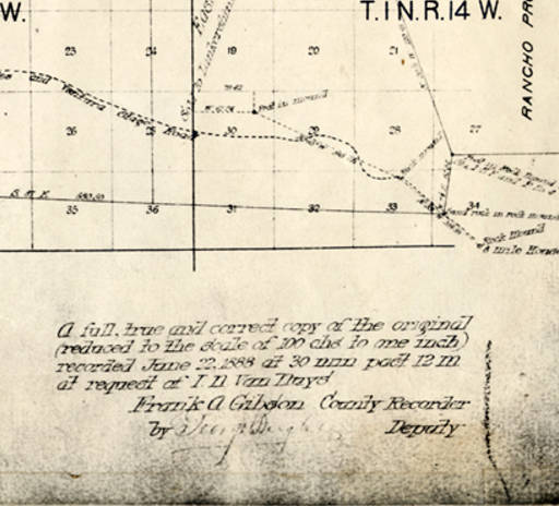
A portion of a map of the lands held by the San Fernando Farm Homestead Association, recorded in 1888. From the Leonis Adobe and Plummer House and part of the San Fernando Valley History Digital Library project of the California State University, Northridge University Library.
As to the fate of the Kester Ranch, it and the several other distinct properties within the Lankershim-Van Nuys empire were sold in September 1909 to the Los Angeles Suburban Homes Company, a syndicate led by Los Angeles Times publisher and real estate titan, Harry Chandler and comprised of such capitalists as Van Nuys, Moses H. Sherman, Chandler’s father-in-law and Times owner Harrison Gray Otis, Henry Huntington, and others.
Not surprisingly, these wealthy and well-connected men were well aware of the coming of the Los Angeles Aqueduct, which would transform the San Fernando Valley and other areas of the region with unbounded (well, until recently) supplies of water from the Owens Valley of eastern California.
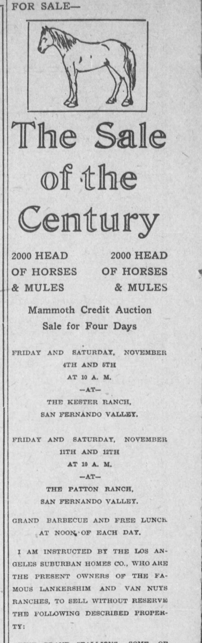
In 1910, the firm announced the “Sale of the Century” (which was saying something, given that the 20th century was still in its childhood) and the above ad from the Herald indicated part of a massive auction was to be held at the Kester Ranch in early November, at which 2000 horses and mules and much more were to be sold.
The development of the several ranches of the Lankershim-Van Nuys holdings for towns, smaller farm and orchard sites and other elments was on and the Kester Ranch became part of the community of Van Nuys.